In the Brazilian backlands, the jurema is a most willful tree: When you think it’s dead, it sprouts again. You can cut it, tear it down, burn it; at the first thunderstorm, its leaves tear through the soil again in search of light.
Same thing for the Kapinawá, a people for whom jurema is the most sacred of plants, a cosmic bridge between the living and the spirits. They, too, when believed extinct, resurfaced.
“And, as the jurema sprouts again, its branches grow even stronger,” emphasizes Mocinha Kapinawá.
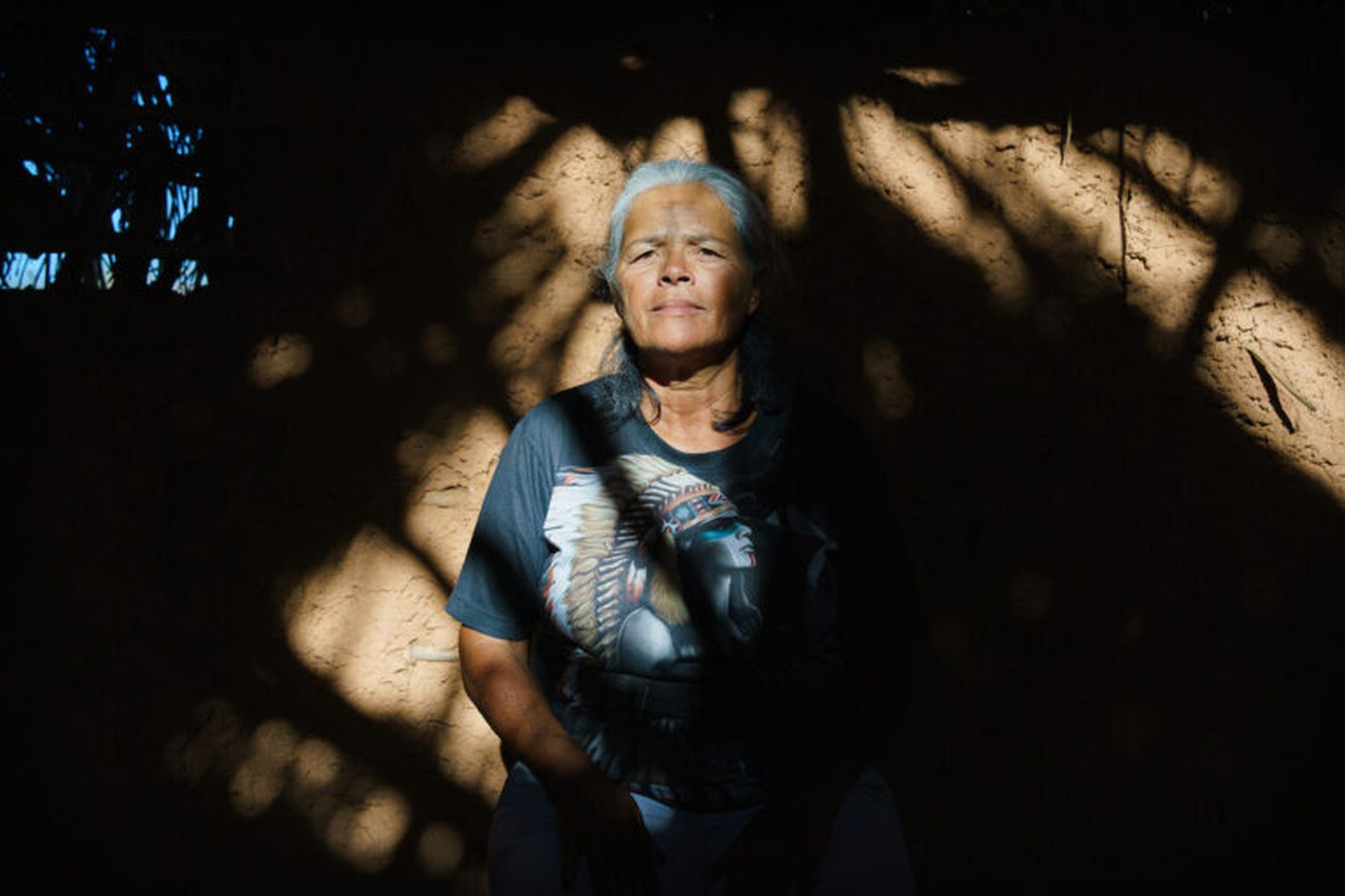
It happened during the Cutting of the Wires. When Maria Bezerra da Silva – known today as Mocinha Kapinawá, a leader in Mina Grande village – was still a teenager, but already on the frontline in the fight against Colonel Romero Maranhão and his land-grabbers.
Mocinha recounts that, since the mid-1970s, the residents of Mina Grande, now the largest village in the Kapinawá territory, had been under pressure from farmers wanting to take over their lands “because of the wealth we have here, which is water.”
Indeed: The Kapinawá territory coincides, geographically, with the Catimbau Valley, a privileged point in the hinterlands of Pernambuco whose maze of hills stores an abundance of water sources — high-quality water that springs at the foothills, irrigates the vegetation and quenches the thirst of those in need.
It was on the outskirts of Mina Grande — a name that means ‘Big Spring’ — that families began to witness the encroachment of wire fences over their fields, pastures and forests, claiming that these were “unclaimed” lands. Zuza Tavares, the leader of the land-grabbers and also the father-in-law of the mayor of nearby Buíque city, was in charge of forging the deeds at the city hall. “That’s when the suffering began,” says Mocinha.
And it began because the Kapinawá did not accept those fences: Systematically, they set out to cut and burn any wire that rose on their lands. In retaliation, the farmers responded with death threats, demolished houses and burned fields. In 1981, in the village of Catimbau, close to Mina Grande, there was a shootout with gunmen hired by the land-grabbers, resulting in the death of two of them.
That happened while the Kapinawá were also discovering themselves as Indigenous people. Before that, they had become used to being called caboclos, a generic and derogatory term in the backlands for the local population whose ancestry is unknown, and so they were believed to be until a document signed by the Emperor’s daughter proved otherwise.
In the same decade of the 1970s, a group of villagers from Mina Grande went to work on the construction of a road in nearby Ibimirim, the land of the Kambiwá people. They were the ones who mentioned the existence of a deed from when Brazil was an empire, dated 1874, specifying a donation of lands to the residents of the village of “Macaco dos Índios,” in gratitude for their participation in the Paraguayan War.
Well, Macaco is not only the name of one of the oldest villages in the Kapinawá territory, but the document also detailed all the boundaries of the donated lands, including the names of the benefiting families, whom the Kapinawá recognized as their ancestors. Further research revealed that the village of Macaco had been known since the 17th century as a home for Indigenous people, at that time referred to as Paratió (or Prakió), related to the Kambiwá.
Therefore, everything suggested that these Paratió were the same Kapinawá of today, forgotten of their past and — more importantly — unaware that they were rightful owners of those lands, with the blessing of the emperor.
Like the jurema tree, the Kapinawá reemerged with increased strength on Caatinga soil, no longer as “caboclos,” but as Indigenous people. Reborn, they gave themselves a new name, revealed in ritual by the spirits, whose meaning would be “grass and water,” two resources that abound in the territory.
The kinship and proximity to the Kambiwá people helped, so much so that two of them ended up becoming masters of the Kapinawá on their journey of self-recognition. Dôca and Zé Índio were the first chief and shaman of the Kapinawá, responsible for reteaching long-forgotten practices, including the toré.
Toré is a ritual common to several Indigenous groups in the Brazilian northeast and is based on the consumption of anjucá, or “jurema wine,” a sacred drink made from the Mimosa tenuiflora tree whose magical power leads people into a trance and contact with the encantados — spiritual forces linked to the ancestors and nature. “Jurema is a mother to us,” summarizes Mocinha.
Knowing they were Indigenous, and strengthened by the toré, the Kapinawá engaged in a conflict that lasted three years, with repeated wire cuttings. Whenever the land-grabbers put up a fence, the Mina Grande families quickly brought it down.
“We danced the ritual at night and went out with a scythe at 3 a.m. to cut the wires. Children, the elderly, everyone. Then we burned it,” says Mocinha. “To sum it up, we cut the wire seven times. With the power of the encantados, we succeeded.”
Those inside and those outside
On the last wire cut, the farmers gave up. For the Kapinawá, a new struggle began, that of recognition by the Brazilian authorities as Indigenous people and legal owners of their territory — a long process that only materialized in 1998, when the Kapinawá Indigenous land was finally ratified, with an area of 12,260 hectares (30,295 acres).
The reserve, now with 14 villages, roughly corresponds to the extent of the land donated by the empire in 1874, delimited by the Macaco and Catimbau streams to the south and north, respectively. The issue is that there were also Kapinawá villages beyond the Catimbau Stream, even farther north, which were left outside the Indigenous land.
“The chief at the time didn’t take into account the families that were spread out on this side,” says Socorro Kapinawá (surnamed Silva França), a leader of the Malhador village, the largest in the so-called New Area, outside the reserve.
As the journey of indigeneity recognition was concentrated in Mina Grande and neighboring villages, where the struggle for territory was also more violent, it’s said the communities north of the Catimbau Stream, like Malhador, remained somewhat alien to this process. At the time of demarcating the Indigenous land, not all of them wanted to get involved.
“It’s kind of complicated to say this, but when they came to demarcate the land, there were villages that didn’t want to participate,” reveals Mocinha.
Anthropologist José Augusto Laranjeiras Sampaio, known as Guga, director-adviser of the National Association for Indigenist Action (ANAI) and professor at the State University of Bahia (Uneb), has closely followed the Kapinawá since the time of Cutting of the Wires.
He confirms Mocinha’s statement: “When they were surveying the land, not every community felt comfortable submitting to Funai [the National Indigenous Peoples Foundation]. And as these communities were not being threatened, Funai left them out.”
Not that they didn’t experience their own land struggle. The lands there had been titled by adverse possession to individuals and then sold to landowners. Many Kapinawá families were expelled in this process; others became tenants of the occupied territories, and a few resisted, confined to a dozen villages.
When these villages also decided to fight for their territory, it was too late: just four years after the Indigenous reserve on the other side of the stream was ratified, the Kapinawá New Area was converted into a national park.
A large stone slate
There were many reasons for the creation of the Catimbau National Park in 2002. This area has some of the greatest biological and geological diversity in the Caatinga biome: a cluster of mountains, valleys, gorges, caves, plateaus and rock formations where 613 species of plants grow — including Cerrado enclaves, rainforests and rocky fields. At least 192 species of birds have been recorded here, in addition to many endemic reptiles.
Moreover, the Catimbau landscape — remarkably beautiful, by the way — has been a landing and passing place for Indigenous peoples for 6,000 years, as evidenced by numerous bones and stone inscriptions throughout the region.
The Catimbau National Park has the second-largest concentration of rock paintings in Brazil — 64 cataloged archaeological sites — second only to Serra da Capivara, also in the northeast region. A large stone slate that Ronaldo Kapinawá knows very well.
“The national park was my childhood amusement park,” says Ronaldo Siqueira, Socorro’s son, a tourist guide and an archaeologist who graduated from the Federal University of Cariri, in Ceará state, where he went to study the official version of Indigenous people’s history and then returns home and rewrites it according to the Kapinawá version.
“See this drawing here, which archaeologists interpret as a hand?” says Ronaldo, showing one of the park’s cave paintings on his cellphone. “For me, it’s something else,” he assures, and then raises his eyes to the panoramic view of the valley unfolding at his feet. “Look at these palm trees in the landscape. See if this painting isn’t a set of babassu palms? It has nothing to do with a human hand. So much so that the thumb doesn’t even appear.”
For Ronaldo Kapinawá, the Catimbau letreiros (signs), as the rock inscriptions are locally called, are topographic maps that people passing through the region drew to indicate water, fruits and game in the area. Each image, a signal: palm grove, riverbed, rock formation.
“It’s already the fourth map that I can identify here in the valley,” he says, showing yet another archaeological site on his cellphone, with the certainty of someone who is intimate with both the territory where he was born and the art that was inscribed there, possibly left by his ancestors. “I have this vision because my perspective is Native. I am a historian of my own history.”
“And I have a great teacher who tells me what each drawing means,” Ronaldo reveals, somewhat enigmatic. “It’s the old trunk of the Kapinawá, all those who have passed away and left their history recorded. Great-grandfathers, great-great-grandfathers; they are here spiritually, they guard these sites. For me, it’s like reading a book they wrote.”
However, despite all the evidence of the continued presence of Native people in the valley, not a single Indigenous person was consulted when the federal government decided to allocate 62,300 hectares (154,000 acres) for the creation of a national park.
‘So we went into battle’
“Catimbau National Park was created without any fieldwork. It was created with aerial photos,” says anthropologist Guga Sampaio. “This is very common in Brazil: You see from above that there are few people living there, and you create a park in the areas that traditional communities have preserved. Then you remove those who preserved it.”
There was indeed an attempt to remove the 45 families living in the area at the time by Brazil’s environmental agencies, with several intimidating meetings with the authorities.
There were six Kapinawá villages entirely within the park, in addition to another six in an intermediate zone between the Indigenous land and the national park, outside both but using the latter’s perimeter for hunting, goat farming and fruit collection. In total, 147 families were affected.
“We were quite peaceful, and suddenly a national park shows up without consulting us,” says Socorro Kapinawá, sitting on the porch of her house in Malhador village, facing a vast Caatinga area that she herself has been working to preserve.
“And we suffered a lot of pressure at that time. The IBAMA [Brazil’s main environmental agency] representative came up to us and said, ‘You’re getting out of here.’ So we went into battle. We sought the organizations that could defend and help us.”
Among these organizations were the Indigenous Missionary Council (CIMI) and ANAI, this one represented by Guga Sampaio, who played a crucial role in mediating the process of the communities’ self-identification as Indigenous with Funai, two decades after the Mina Grande people.
“Only when the park was created, with restricted use, did the communities say, ‘We are Indigenous here,’” recalls Guga, justifying the delay compared with other Kapinawá: “Being Indigenous in Brazil is difficult, you suffer like hell. You have to have a good reason to say that you’re Indigenous. That is, when you’re threatened.”
Recognition came, but the struggle didn’t stop. It even gained an air of war when, in 2011, the Kapinawá learned that the headquarters of a farm within the national park would be transformed into a lodge. Led by Malhador village, families from almost all 26 Kapinawá villages marched to the main house and took possession of it, in a process that became known as Recoupment.
What has been established since then, and continues to this day, is a coexistence agreement between the Indigenous people and the national park management authorities — except, of course, for the restrictions that by law apply to any Full Protection Conservation Unit in Brazil. And it’s because of these restrictions that tension persists.
A park in the way
“We have to ask their permission for everything,” complains Socorro Kapinawá. “You can’t put electricity in your home without asking the national park manager. You can’t dig a well. You can’t remove material to fix the roads. We have a first-class material here, which is piçarra [a type of gravel], that water doesn’t wash away. There’s a lot of sand here; it’s not possible to drive. But they won’t let us take it.”
And she goes on: “If we need wood to fix a fence, to build a house, we have to ask permission to get it from the valley. But we know the Caatinga, and we know which trees sprout again after cutting, the ones that have this regenerative power. They want to stop us from doing something that we know how to do and have been preserving for so long.”
To these complaints, Jailton Fernandes, head of Catimbau National Park since 2021, responds by saying, “We do not oppose road repairs. The problem is that they want to take it from inside the park. It will change the landscape. There needs to be a project for us to authorize.”
Regarding the removal of wood, Jailton says, “there’s no problem collecting within one’s area. We don’t prohibit it. They know how to do it, they let it regenerate. If there’s no environmental damage, we authorize it. What can’t be done is clear-cutting and selling wood.”
In fact, both Socorro and Jailton agree there are cases of illegal wood removal from inside the national park. “The Indians even communicate when there’s an environmental violation,” says the head of the park.
But Socorro asks for more: “We want to partner up to defend the Caatinga, catch those who cut wood, trap birds to sell them, but they don’t monitor them.” Jailton argues, “We’re only two permanent employees here – and I am one of them.”
For Socorro, however, the most painful thing is the restricted access to places that the Kapinawá consider sacred. Jailton says the Indigenous people are free to move around the park, but Socorro insists, “There are many places we can no longer go because they have become tourist spots. Now we have to go as tourists, not as children of the land.”
One such place is the Sanctuary, a natural sandstone amphitheater sculpted by water and wind, which, according to Socorro, is the “dwelling of the encantados, a very sacred place.”
And, like this one, “There are many places that are now tourist routes that have always been sacred. And will always be. But we can no longer walk there. We can no longer perform a ritual. We have to look from afar, just wishing to do it,” she says, with tears in her eyes.
“It’s in the forests that the encantados live,” explains Mocinha. “When we need to fortify ourselves, we put our feet on the ground. We go to the forest and ask for strength from our ancestors.”
A jurema wine-fueled toré ritual usually takes place in the central hut of the villages, but it’s not rare to also be held in the middle of the Caatinga forest — especially if it involves a healing ritual — or inside the many caves that spread across the Catimbau Valley.
These caves, the Kapinawá call furnas, and most of them are full of rock engravings — for the Indigenous people, unequivocal proof that their ancestors passed through here (and indeed, many burials have been found here). “These places give us strength. That’s where our ancestors are,” says Ronaldo.
These ancestors, according to the Kapinawá, became encantados, went to inhabit the magical realm of Juremá, and now they return to Earth whenever summoned through the jurema trance, manifesting as caboclos or “masters.” These masters, as Ronaldo explains, are the very personification of the Caatinga trees: Master Aroeira, Master Angico, Master Jatobá. …
In Kapinawá lands, the Caatinga is food that strengthens body and soul. When it’s not the encantados, it’s the flesh of the fruits and the veins of the leaves that serve as sustenance, foundation and healing. Especially in times of scarcity.
Take, for example, the ouricuri (Syagrus coronata), “our wet nurse,” according to Mocinha. “We use it for everything.” From the coconut of this native palm tree, they extract milk and oil. From the trunk comes the heart of palm and bró, a type of flour. From the straw, they make the roofs of the huts and the traditional Kapinawá hat. From the roots, they can make a medicinal tea that relieves back pain. “The ouricuri is one of the most sacred plants for us,” summarizes Socorro.
And there are many others: caroá, bacupari, cambuí, maçã-do-mato, aroeira, sacatinga, baraúna – fruits for eating, straws for braiding and herbs for healing that only the Caatinga provides. “I haven’t been to the hospital for over 10 years. My cure is here, with the encantados and the plants of the Caatinga,” says Ronaldo.
It’s clear, therefore, that the Kapinawá will not give up this territory that is a temple, pantry and pharmacy so soon. “We just want to have the free will to live in our spaces, to be able to enjoy our land without them breathing down our necks,” says Socorro. “We’re in what is ours; they’re the ones who arrived later.”
“There is a process stuck at Funai,” says anthropologist Guga Sampaio, who is closely following the Kapinawá struggle. “The solution that is being given is what they call dual allocation,” he explains. “To avoid uncreating a national park, you establish an Indigenous land in the form of shared management.”
Guga says the model was initially adopted on Bananal Island, in Tocantins state, now both Araguaia National Park and Inãwébohona Indigenous Land, where the Karajá and Javaé people live. The same thing in the Amazon state of Roraima, where the Raposa Serra do Sol Indigenous land overlaps Monte Roraima National Park. “And it has worked well here on Monte Pascoal, in Bahia, where the Pataxó people live,” says Guga.
In Catimbau, he argues, “As we know that the demarcation will take time, we see that the coexistence efforts are going well. What they [the park management] have done is put the Kapinawá as guides and responsible for preservation.”
Jailton, the head of the national park, adds that “in the new management plan, which should be released this year, this coexistence will be defined. Indians and park have the same goal, which is preservation.”
Jurema’s leaflet
So that’s what the Kapinawá are doing. While the law does not grant them the land that is rightfully theirs — and while the few park employees are unable to maintain it — they have decided to take care of Catimbau themselves.
Ronaldo started by recovering a degraded area left by his grandfather 10 years ago. Socorro is busy collecting seeds. “I got obsessed,” she says. “Wherever I go, if I see a seed, I go there and pick it up. When I get home, I immediately put it in a pot.”
And there are countless pots on Socorro’s porch, whose seedlings will one day be trees like those already growing in the backyard, including an angico, a mandacaru cactus and a 6-year-old jucá where “you can already sit in the shade. … When I saw that I had such a big yard at home, I decided I was going to start remaking the Caatinga here.”
Recaatingamento is the name given to a series of practices that seek to recover the Caatinga dry forest in degraded areas, protecting it from goat herds, reforesting and, “planting water,” as they say here. “We make small embankments where this water will be stored and return to the soil, irrigating the groundwater,” explains Ronaldo.
All this in the midst of productive backyards. “We call it agrocaatinga,” says Socorro, where forests and fields work together to increase food security, making Malhador village the largest agroecology laboratory in the Kapinawá territory.
An experiment center has the Saturnino Vieira de Melo Indigenous school at its core, where Ronaldo is the coordinator and where dozens of children learn to recaatingar the Kapinawá territory themselves.
From the geodesic dome that serves as a nursery, 2,000 seedlings of ipê, imburana, jatobá and many other Caatinga trees have already been donated to families throughout the territory for them to plant on their land.
“We’re passing on to children these teachings that come from the ancestors,” Ronaldo says. “Doing this by recaatingamento, reforesting, planting water. Creating this link between people and the territory.”
“The Caatinga has a very strong regenerative power,” says Socorro. “When you think a tree is dead, it rains, and 15 days later, you see the strength with which the new leaves come. How is such land weak?”
Even more so, if it’s Kapinawá land, a people where children are initiated from an early age not only into caring for the Caatinga but also into connecting with its magical power. “Even children drink jurema wine,” says Socorro. “To prepare tomorrow’s warriors, you have to start today, right? They take part in every toré.”
Mocinha confirms: “We are jurema seeds.” And then she starts singing the song that ends every toré, whose melody doesn’t break alone the silence of the Mina Grande’s central yard because suddenly the wind blows, and it seems that all the trees decide to sing with her: “The leaflet of jurema/that the wind is carrying /it goes on and on and on/and the caboclos follow along …”
Citations:
Athiê-Souza, S. M., Melo, J. I., Silva, L. P., Santos, L. L., Santos, J. S., Oliveira, L. D., & Sales, M. F. (2018). Phanerogamic flora of the Catimbau National Park, Pernambuco, Brazil. Biota Neotropica, 19(1). doi:10.1590/1676-0611-bn-2018-0622
Las-Casas, F. M., Da Pereira, I. M., Dos Santos, L. D., & Naka, L. N. (2019). The avifauna of the Catimbau National Park, an important protected area in the Brazilian semiarid. Revista Brasileira de Ornitologia, 27(2), 79-93. doi:10.1007/bf03544452
This article appeared originally in Mongabay. Read the original article here:
https://news.mongabay.com/2024/02/in-the-brazilian-outback-the-half-century-kapinawa-struggle-for-sacred-ground/
